|
1.1 "Air traffic incident" is used to mean a serious occurrence related to the provision of air traffic services, such as:
|
|
|
|
a) aircraft proximity (AIRPROX);
|
|
b) serious difficulty resulting in a hazard to aircraft caused, for example, by:
|
|
1) faulty procedures;
|
|
2) non-compliance with procedures; or
|
|
3) failure of ground facilities.
|
|
|
|
1.2 Definitions for aircraft proximity and AIRPROX.
|
|
|
|
Aircraft proximity.
A situation in which, in the opinion of the pilot or the air traffic services personnel, the distance between aircraft, as well as their relative positions and speed, has been such that the safety of the aircraft involved may have been compromised. Aircraft proximity is classified as follows:
|
|
|
|
Risk of collision.
The risk classification of aircraft proximity in which serious risk of collision has existed.
|
|
|
|
Safety not assured.
The risk classification of aircraft proximity in which the safety of the aircraft may have been compromised.
|
|
|
|
No risk of collision.
The risk classification of aircraft proximity in which no risk of collision has existed.
|
|
|
|
Risk not determined.
The risk classification of aircraft proximity in which insufficient information was available to determine the risk involved, or inconclusive or conflicting evidence precluded such determination.
|
|
|
|
AIRPROX.
The code word used in an air traffic incident report to designate aircraft proximity.
|
|
|
|
|
|
1.2 Air traffic incidents are designated and identified in reports as follows:
|
|
Type
|
Designation
|
|
Air traffic incident
|
Incident
|
|
as a) above
|
AIRPROX (aircraft proximity)
|
|
as b) 1) and 2) above
|
Procedure
|
|
as b) 3) above
|
Facility
|
|
1.14.2 Use of the Air Traffic Incident Report Form
(See model on pages ENR 1.14-4 to 1.14-8)
|
|
|
|
The Air Traffic Incident Report Form is intended for use:
|
|
|
|
a) by a pilot for filing a report on an air traffic incident after arrival or for
confirming a report made initially by radio during flight.
|
|
Note.- The form, if available on board, may also be of use in providing a pattern
for making the initial report in flight.
|
|
|
|
b) by an ATS unit for recording an air traffic incident report received by radio,
telephone or teleprinter.
|
|
Note.- The form may be used as the format for the text of a message to be
transmitted over the AFS network
|
|
|
|
1.14.3 Reporting procedures
(including in-flight procedures)
|
|
|
|
3.1 The following are the procedures to be followed by a pilot who is or has been
involved in an incident:
|
|
|
|
a) during flight, use the appropriate air/ground frequency for reporting an incident of
major significance, particularly if it involves other aircraft, so as to permit the
facts to be ascertained immediately;
|
|
b) as promptly as possible after landing, submit a completed Air Traffic Incident
Report Form
|
|
1) for confirming a report of an incident made initially as in a) above, or for
making the initial report on such an incident if it had not been possible to report
it byradioby radio;
|
|
2) for reporting an incident which did not require immediate notification at the
time of occurrence.
|
|
|
|
3.2 An initial report made by radio should contain the following information:
|
|
|
|
a) aircraft identification;
|
|
b) type of incident, e.g. aircraft proximity;
|
|
c) the incident; 1. a) and b); 2. a), b), c), d), n); 3. a), b), c), i); 4. a), b);
|
|
d) miscellaneous: 1. e).
|
|
|
|
3.3 The confirmatory report on an incident of major significance initially reported by radio or the initial report on any other incident should be submitted to The Aviation Safety Board, or to the ATS Reporting Office of the aerodrome of first landing for submission to The Aviation Safety Board. The pilot should complete the Air Traffic Incident Report Form, supplementing the details of the initial reports as necessary.
|
|
|
|
Note.- Where there is no ATS Reporting Office, the report may be submitted to
another ATS unit.
|
|
|
|
|
|
1.14.4 Purpose of reporting and handling of the form
|
|
|
|
4.1 The purpose of the reporting of aircraft proximity incidents and their investigation is to promote the safety of aircraft. The degree of risk involved in an aircraft proximity incident should be determined in the incident investigation and classified as "risk of collision", "safety not assured", "no risk of collision" or "risk not determined".
|
|
|
|
4.2 The purpose of the form is to provide investigatory authorities with as complete information on an air traffic incident as possible and to enable them to report back, with the least possible delay to the pilot or operator concerned, the result of the investigation of the incident and, if appropriate, the remedial action taken.
|
1.14.5 AIR TRAFFIC INCIDENT REPORT FORM
|
|
|
|
|
|
|
For use when submitting and receiving reports on air traffic incidents. In an initial report by radio, shaded items should be included.
|
|
|
|
|
|
|
A AIRCRAFT IDENTIFICATION
|
B TYPE OF INCIDENT
|
|
|
|
AIRPROX / PROCEDURE / FACILITY*
|
|
C THE INCIDENT
|
|
1. General
|
a)
|
Date / time of incident UTC
|
|
|
b)
|
Position
|
|
|
|
2. Own aircraft
|
a)
|
Heading and route
|
|
|
b)
|
True airspeed ____________________________________ measured in ( ) kt _____ ( ) km/h _____
|
c)
|
Level and altimeter setting
|
|
|
d)
|
Aircraft climbing or descending
|
|
|
|
( ) Level flight
|
( ) Climbing
|
( ) Descending
|
e)
|
Aircraft bank angle
|
|
|
|
( ) Wings level
|
( ) Slight bank
|
( ) Moderate bank
|
|
( ) Steep bank
|
( ) Inverted
|
( ) Unknown
|
f)
|
Aircraft direction of bank
|
|
|
|
( ) Left
|
( ) Right
|
( ) Unknown
|
g)
|
Restrictions to visibility (select as many as required)
|
|
|
( ) Sunglare
|
( ) Windscreen pillar
|
( ) Dirty windscreen
|
|
( ) Other cockpit structure
|
( ) None
|
|
h)
|
Use of aircraft lighting (select as many as required)
|
|
|
( ) Navigation lights
|
( ) Strobe lights
|
( ) Cabin lights
|
|
( ) Red anti-collision lights
|
( ) Landing / taxi lights
|
( ) Logo (tail fin) lights
|
|
( ) Other
|
( ) None
|
|
i)
|
Traffic avoidance advice issued by ATS
|
|
|
( ) Yes, based on radar
|
( ) Yes, based on visual sighting
|
( ) Yes, based on other information
|
|
( ) No
|
|
|
j)
|
Traffic information issued
|
|
|
|
( ) Yes, based on radar
|
( ) Yes, based on visual sighting
|
( ) Yes, based on other information
|
|
( ) No
|
|
|
k)
|
Airborne collision avoidance system ACAS
|
|
|
( ) Not carried
|
( ) Type
|
( ) Traffic advisory issued
|
|
( ) Resolution advisory issued
|
( ) Traffic advisory or resolution advisory not issued
|
l)
|
Radar identification
|
|
|
|
( ) No radar available
|
( ) Radar identification
|
( ) No radar identification
|
m)
|
Other aircraft sighted
|
|
|
|
( ) Yes
|
( ) No
|
( ) Wrong aircraft sighted
|
n)
|
Avoiding action taken
|
|
|
|
( ) Yes
|
( ) No
|
|
o)
|
Type of flight plan
|
IFR / VFR / none*
|
|
|
|
|
|
|
3. Other aircraft
|
a)
|
Type and call sign / registration (if known)
|
b)
|
If a) above not known, describe below
|
|
|
( ) High wing
|
( ) Mid wing
|
( ) Low wing
|
|
|
( ) Rotorcraft
|
|
|
|
|
( ) 1 engine
|
( ) 2 engines
|
( ) 3 engines
|
|
|
( ) 4 engines
|
( ) More than 4 engines
|
|
|
Marking, colour or other available details
|
c)
|
Aircraft climbing or descending
|
|
|
|
( ) Level flight
|
( ) Climbing
|
( ) Descending
|
|
( ) Unknown
|
|
|
d)
|
Aircraft bank angle
|
|
|
|
( ) Wings level
|
( ) Slight bank
|
( ) Moderate bank
|
|
( ) Steep bank
|
( ) Inverted
|
( ) Unknown
|
e)
|
Aircraft direction of bank
|
|
|
|
( ) Left
|
( ) Right
|
( ) Unknown
|
f)
|
Lights displayed
|
|
|
|
( ) Navigation lights
|
( ) Strobe lights
|
( ) Cabin lights
|
|
( ) Red anti-collision lights
|
( ) Landing / taxi lights
|
( ) Logo (tail fin) lights
|
|
( ) Other
|
( ) None
|
( ) Unknown
|
g)
|
Traffic avoidance advice issued by ATS
|
|
( ) Yes, based on radar
|
( ) Yes, based on visual sighting
|
( ) Yes, based on other information
|
|
( ) No
|
( ) Unknown
|
|
h)
|
Traffic information issued
|
|
|
|
( ) Yes, based on radar
|
( ) Yes, based on visual sighting
|
( ) Yes, based on other information
|
|
( ) No
|
( ) Unknown
|
|
i)
|
Avoiding action taken
|
|
|
|
|
( ) Yes
|
( ) No
|
( ) Unknown
|
|
4. Distance
|
a)
|
Closest horizontal distance
|
|
|
b)
|
Closest vertical distance
|
|
|
|
5. Flight weather conditions
|
a)
|
IMC / VMC*
|
|
|
b)
|
Above / below* clouds / fog / haze or between layers*
|
c)
|
Distance vertically from cloud __________ m / ft* below __________ m / ft* above
|
d)
|
In cloud / rain / snow / sleet / fog / haze*
|
e)
|
Flying into / out of* sun
|
|
|
f)
|
Flight visibility _______ m / km*
|
|
|
|
6. Any other information considered important by the pilot-in-command
|
|
D MISCELLANEOUS
|
|
|
|
1. Information regarding reporting aircraft
|
|
|
a)
|
Aircraft registration
|
|
|
b)
|
Aircraft type
|
|
|
c)
|
Operator
|
|
|
d)
|
Aerodrome of departure
|
|
|
e)
|
Aerodrome of first landing
|
destination
|
|
_______________________
|
|
|
f)
|
Reported by radio or other means to _______________________________________ (name of ATS unit) at time UTC
|
g)
|
Date / time / place of completion of form
|
|
|
|
2. Function, address and signature of person submitting report
|
a)
|
Function
|
|
|
b)
|
Address
|
|
|
c)
|
Signature
|
|
|
d)
|
Telephone number
|
|
|
|
3. Function and signature of person receiving report
|
|
a)
|
Function
|
b)
|
Signature
|
|
________________________________
|
__________________________________________
|
|
E SUPPLEMENTARY INFORMATION BY ATS UNIT CONCERNED
|
|
1. Receipt of report
|
|
|
a)
|
Report received via AFTN / radio / telephone / other (specify)*
|
|
______________________________
|
|
|
b)
|
Report received by __________________________________ (name of ATS unit)
|
|
2. Details of ATS action
|
|
|
|
Clearance, incident seen (radar/visually, warning given, result of local enquiry, etc.)
|
|
_____________________________________________________________________________________________________________________ ______
______
|
|
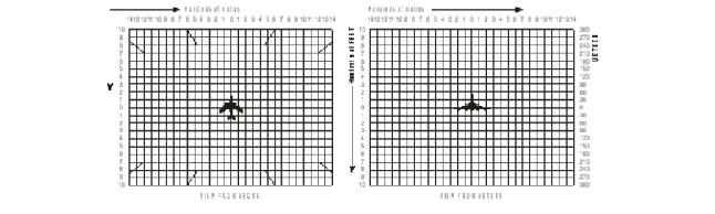
DIAGRAMS OF AIRPROX
|
|
|
|
Mark passage of other aircraft relative to you, in plan on the left and in elevation on the right, assuming YOU are at the centre of each diagram. Include first sighting and passing distance.
|
|
1.14.6 Instructions for the completion of the Air Traffic Incident Report Form
|
|
|
|
Item
|
|
|
|
|
|
A
|
Aircraft identification of the aircraft filing the report.
|
|
|
|
|
B
|
An AIRPROX report should be filed immediately by radio.
|
|
|
|
|
C1
|
Date/time UTC and position in bearing and distance from a navigation aid or in LAT/LONG.
|
|
|
|
|
C2
|
Information regarding aircraft filing the report, tick as necessary.
|
|
|
|
|
C2 c)
|
E.g. FL 350/1 013 hPa or 2 500 ft/QNH 1 007 hPa or 1 200 ft/QFE 998 hPa.
|
|
|
|
|
C3
|
Information regarding the other aircraft involved.
|
|
|
|
|
C4
|
Passing distance - state units used.
|
|
|
|
|
C6
|
Attach additional papers as required. The diagrams may be used to show aircraft's positions.
|
|
|
|
|
D1 f)
|
State name of ATS unit and date/time in UTC.
|
|
|
|
|
D1 g)
|
Date and time in UTC.
|
|
|
|
|
E2
|
Include details of ATS unit such as service provided, radiotelephony frequency, SSR Codes assigned and altimeter setting. Use diagram to show the aircraft's position and attach additional papers as required.
|